Introduction
 |
Some of the new charts for my round
GB trip. |
Unless you are always eating at expensive restaurants and drinking serious malts and wine the most expensive part of a round GB or UK & Ireland trip is likely to be the charts and pilots needed.
And don't forget to budget for electronic charts for the plotter and any navigation software. An electronic tidal stream atlas and tide tables are also useful, "Imray Tides" on iPad is good or, at a price, the Admiralty "Total Tide" application on PC is the most accurate available.
For the Scottish Islands copies of the "Antares charts" are well worth the investment, just £15 for over 500 very detailed charts of small areas and very useful information on each anchorage, they will require a free or cheap viewer if your navigation software does not support the format. Or for £20 you can get MemoryMap software which works well with Antares charts and can be run on multiple PC, Mac, iPad, or Android devices with one licence.
The Memory map software also supports UKHO charts that are very good value, and gets you the full set of 850 charts covering UK and Ireland with seamless integration with the Antares charts. I have now discontinued my Imray Navigator update subscription in favour of Memory Map.
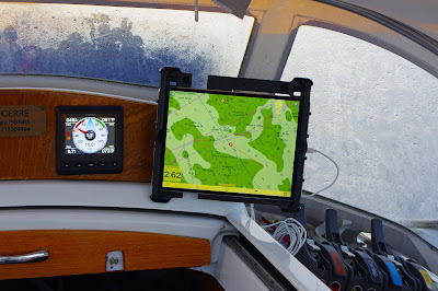 |
The Memorymap app displaying an Admiralty chart as I wend
my way out of the Isles of Scilly, not long after low water. |
Update: At the end of March 2021 this arrived in my in box.
"These charts are now only available as an annual subscription, with map updates, for £25. This means that you receive a free update when the 2022 edition is released, but your license to use the maps expires 1 year from your purchase. The reason we are not offering a perpetual license is that the best naviational [sic] practice is to use the latest available charts. The subscription license ensures that you always have access to the latest charts."
Paper Charts
In my view paper charts are a must have as a back up to electronic ones, even though I have multiple systems, for that purpose Imray C series (see below) are adequate most of the time but I prefer to have larger scale paper charts, preferable in A2 size, for pilotage and when sailing close to the shore. To reduce weight and volume I now remove pages I am very unlikely to use such as charts of purely commercial ports or areas I have no intention of visiting, another good reason for have them loose leaf rather than spiral bound.
The first thing to decide is which parts of the trip will be passage making and which areas you want to explore in detail, for the later the best option will be Admiralty Leisure folios (if they are still available Update Feb 2022: now discontinued, see below 😒) or the Imray equivalents.
For the passage making sections the best option is likely to be Imray C series charts, they are not my favourite representations (They are a bit "busy" and I find the colour schemes hard to read at night) but they cover a longish stretch of the coast and have inset chart-lets of most ports, harbours and estuaries that you may want to put into for shelter, so are usually the most economical back up for your chart plotter. Note that the scale of the costal c series charts varies from 1:80,000 - 1:120,000 in "popular" areas on the south coast to 1:200,000 - 1:285,000 for much of Ireland and Scotland so scale does not equate to the number of dangers on a piece of coast.
But check the coverage of each vs the leisure and Imray 2000 series folios, sometimes one of those will be the better option, for example the Imray folio 2100 covers Chichester harbour right round to Burnham-on-Crouch.
Even when planning I find it easier to visualise a route from a paper chart than on a computer screen, even the big 21" one I have at home and more so when using the 11" on the lap top I use on the boat. So if in doubt and the budget will stretch then go for the A2 charts packs, especially if you are likely to be coming back to the area, but make sure you have a few smaller scale charts for initial passage planning.
The Admiralty folios have more and larger scale charts for a given area than Imray, cover some areas that Imray does not and in my view are better value, which with higher production cost, is probably why the hydrographic office is going to discontinue them, despite protests from many individuals and organisations. Whilst they are still available check out the coverage and orientation of each, in some areas the coverage, segmentation and orientation, is better on one than the other. Also check the issue date of both, one could be several years older which at the least means a lot of correcting and in some cases individual charts can't fully updated.
Update Dec 2021:
Amendments will be being issued until December 2022, after that the individual charts will be available at £15 each with a maximum discount of 75% for >= 15, so all of the charts in Folio 5611 - West Coast of Scotland, Mull of Kintyre to Point of Ardnamurchan would cost £93.75 up from c £45. And there is an implication that the charts are likely to only be available from specialist companies who can do Print on Demand.
At these prices they are unlikely to be economic when a large area needs to be covered and certainly not competitive with Imray.
Back to back printing, used by both publishers and becoming ubiquitous with the new Imray wire bound atlas, saves a little space and quite a bit of weight but is not as convenient as they can be difficult to sequence on the chart table and have to be turned over, .
My cruising area on my round GB trip was intended to be the Scottish Islands and possibly Orkney and Shetland. I made it to Orkney but I did not have time to go to Shetland. These are the charts I took, plus those for Jester Baltimore trips and a probable round Ireland trip and those covering the channel that are always on board, if I was starting from scratch I might have chosen slightly differently but not much:
Admiralty Folios:
 |
Leisure Folio charts in artist's
display folios. |
SC5600 Solent and approaches.- SC5604 Channel Islands.
- SC5609 North West Wales including Menai Straits (not yet used as I ended up going up the coast of Ireland due to weather and Covid-19 delays making a trip through the straights impractical especially with the tides out of sync).
- SC5611 West Coast of Scotland - Mull of Kintyre to Point of Ardnamurchan.
- SC5616 Scotland West Coast - Point of Ardnamurchan to Shiant Islands.
- SC5622 Ireland South Coast, Waterford to Kinsale.
- SC5623 Ireland, SW Coast.
As things turned out SC5621 Ireland East Coast (since purchased for a different trip) would have been nice and could have replaced C61 but the later was adequate.
There is an annoying gap between set SC5623 and Imray C55, you either need Imray C56 @ 1:200,000 which duplicates much of SC5623 at a smaller scale but with some useful chart-lets, Admiralty 2423 Mizen Head to Dingle Bay @ 1: 150,000 or preferably the more expensive option of Admiralty 2495 Kenmare river largely @ 1:30,000 (Dursey Sound 1:12:500) and 2789 Dingle Bay and Smerwick Harbour @ 1:60,000.
Imray Folios:
- 2100 Kent and Sussex Coasts Chart Atlas.
- 2300 Devon & Dorset.
- 2400 West Country Chart Atlas (incl. Scilly).
- 2510 North Brittany.
Imray Single Charts:
- C1 Thames Estuary (Not strictly necessary as C28 and 2100 cover the area but this one makes is much easier to visualise the entire route from the Downs to north of Felixstowe through all of the banks and restricted areas.
- C6 Salcombe to Lizard Point. C6 and C7 are not strictly necessary as they are covered by folios but the folio sheets frequently are not conveniently segmented, these give good overviews and make for easier course plotting.
- C7 Falmouth to Scilly & Trevose Head.
- C10 Western English Channel Passage Chart (for the JBC).
- C18 Western Approaches to the English Channel & Bay of Biscay.
- C23 Fife Ness to Moray Firth.
- C24 Flamborough Head to Fife Ness.
- C29 Harwich to Whitby
- C53 Donegal Bay to Rathlin Island.
- C54 Galway Bay to Donegal Bay.
- C55 Dingle Bay to Galway Bay.
- C61 St George's Channel.
- C62 Irish Sea.
- C63 Firth of Clyde (Not used - yet).
- C64 North Channel.
- C67 North Minch and Isle of Lewis.
- C68 Cape Wrath to Wick and the Orkney Islands.
Admiralty Single Charts:
- 35 Scapa Flow & approaches, not really necessary but I took it because of my interest in the areas Naval history.
- 123 Western Approaches to Saint George's Channel and Bristol Channel (used for the JBC).
- 1942 Fair Isle to Wick
- 2502 Eddrachillis Bay (there was a couple of places I thought I might go to (and did, although not #1 on the list) that were off of folio 5615 and not covered by C67).
- 2722 Skerryvore to Saint Kilda.
- 2802 Sound of Harris.
- 3282 Shetland Islands North-East Sheet.
- 3283 Shetland Islands South Sheet.
- 2495 Kenmare river 1:30,000 (Dursey Snd 1:12:500)
- 2789 Dingle Bay and Smerwick Harbour 1:60,000
- 1820 Aran Islands to Roonah Head 1:75,000
- 3339 Approaches to Galway Bay including the Aran Islands 1:50,000
Warning!
Updating this number of charts takes a long time - several days in my case.
Chart Storage
 |
| My "C series" charts and most of my pilots. |
The C series charts come folded in wallets so are easy to store in a plastic box. Folios are more problematic, I use a couple of artists A2 folios with plastic sleeves, they work best with the loose leave ones but a pocket at the back will cope with those charts unlikely to be needed and in the newer spiral bound "Atlases" sold by Imray (I prefer the loos leaf ones, preferable single sided as they are easier to organise), a few full size charts can accommodated folded (they are going to be folded on the chart table anyway) or a section of plastic drain pile will take several rolled.
I now make up my own chart folios taking only those likely to needed on the planned route and alternates, especially for places of safety that I might divert to after an electrical failure or to avoid bad weather. Each small folio covers a section of the route in sequence.
When costal sailing I will have the small scale charts on or in the chart table ready for use and the more detailed ones quickly available.
Pilots / Sailing Directions
An excellent free resource is the US Governments Sailing Directions that can be viewed on line or downloaded from
Maritime Safety Information (nga.mil) the UK is covered in 4 documents (links correct March 2023):
On a round Britain trip it would be best to have a comprehensive set of pilots plus a good Almanac - I use Reed's. But some in my view are essentially obligatory, I went the fully Monty for the round GB trip (although I already had several) and had a lot of winter reading as a bonus:
- CCC Firth of Clyde
- CCC Kintyre to Ardnamurchan Pilot.
- CCC Ardnamurchan to Cape Wrath Pilot.
- CCC Orkney & Shetland Islands Pilot 2nd Ed 2020 (This one is particularly important).
- CCC Sailing Directions and Anchorages - Outer Hebrides.
- Shell Channel Pilot 2017 edition.
- RCCPF Isles of Scilly Pilot 5th Ed.
- RCCPF Channel Isles, Cherbourg Peninsula & N Brittany (PlayBook).
- Cruising Scotland (Playbook) - not needed but a decent read with stunning photos almost all in perfect weather!
- Imray Irish Sea Pilot.
- Imray Cook's Country, Spurn Head to St Abbs.
- Imray North Sea Passage Pilot.
- Imray Cruising Cork & Kerry.
- Irish Cruising Club - S & W coasts of Ireland Sailing Directions.


No comments:
Post a Comment